
 Check this out, its super cool.
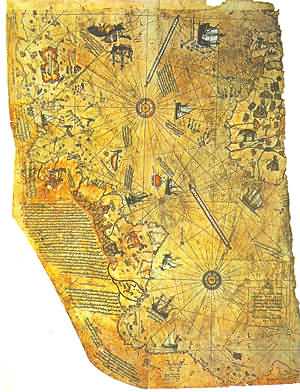
In a nutshell, in 1929 a group of historians found a map drawn on gazelle skin - later proved to have been originally drawn in 1513 by Piri Reis, a famous admiral of the Turkish fleet in the 16th Century. He compiled the data for the map from a large number of source maps, some dated 4th Century BC or earlier.
The Piri Reis map shows the western coast of Africa, the eastern coast of South America, and the northern coast of Antarctica. The northern coastline of Antarctica is perfectly detailed.
Now, beyond the fact that Piri Reis somehow drew a very accurate map of the Antarctic region 300 years before it was discovered, the map also shows the coastline under the ice. Geological evidence confirms that the latest date this land could have been charted in an ice-free state is 4000BC!!! Why is that with explanation marks? Well, according to traditional history, the first civilization developed in the mid-east around the year 3000 BC
What does this mean? Well, if brings up very interesting questions:
* Who mapped the Queen Maud Land of Antarctic 6000 years ago?
* Which unknown civilization had the technology or the need to do that... to be able to do things that NOW are possible with the modern technologies?
Read more here !
---------------------------------------------------------------
* See?! I'm not just about Star Wars and things of Geek!


1 comment:
I watched AvP, I know who mapped Anartica.
geesh duh..
and yes this still counts as nerdy sci-fi
Post a Comment